
Severe Convection
My current and past research interests in this area are:
Large-scale characteristics and convective environments associated with tornado events, particularly in Florida
Dynamics and thermodynamics of non-lake effect snow squalls
Large-scale characteristics and convective environments associated with Mesoscale Convective Complexes (MCCs)
Check out our:
2020 Electronic Journal of Severe Storms Meteorology article on Florida tornado events
2011 and 2014 Weather and Forecasting articles on non lake effect snow squalls (“snowbursts”) in Canada
2013 Electronic Journal of Severe Storms Meteorology article on Central U.S. MCCs
Large-scale characteristics of florida tornado events
Florida sees many tornadoes each year but most are weak and/or associated with tropical cyclones. During the cool season, however, Florida can experience severe convection and occasionally strong tornadoes. Our recent work examined the large-scale characteristics of tornado and null (when tornadoes were forecast but did not occur) events in Florida between 1979 and 2018.
Results found that Florida tornado events were typically characterized by high-shear low-CAPE environments, which are common in southeastern U.S. tornado outbreaks. In addition, Florida tornado events are associated with an amplified mid- and upper-tropospheric height pattern and divergent jet streak regions. Null events tended to be more common in the Florida Panhandle, while tornado events occurred fairly evenly throughout the state.
Pictured below are plots from our 2020 article:
Locations of Florida tornado and null events
250-hPa composite geopotential height and jet streak patterns associated with Florida tornado events
500-hPa composite geopotential height patterns associated with Florida tornado events
Box-and-whisker diagrams of MLCAPE and 0-6-km bulk shear for Florida tornado and null events


Dynamics and thermodynamics of non lake effect snow squalls (“Snowbursts”)
Non lake effect snow squalls are short-lived events that occur away from large bodies of water (e.g., Great Lakes) and are often associated with an arctic cold front. While snowfall accumulations are typically quite small and below warning criteria, these events often pose a large threat to life and property, particularly transportation. Visibility is typically reduced to near zero, resulting in whiteouts and very hazardous travel conditions.
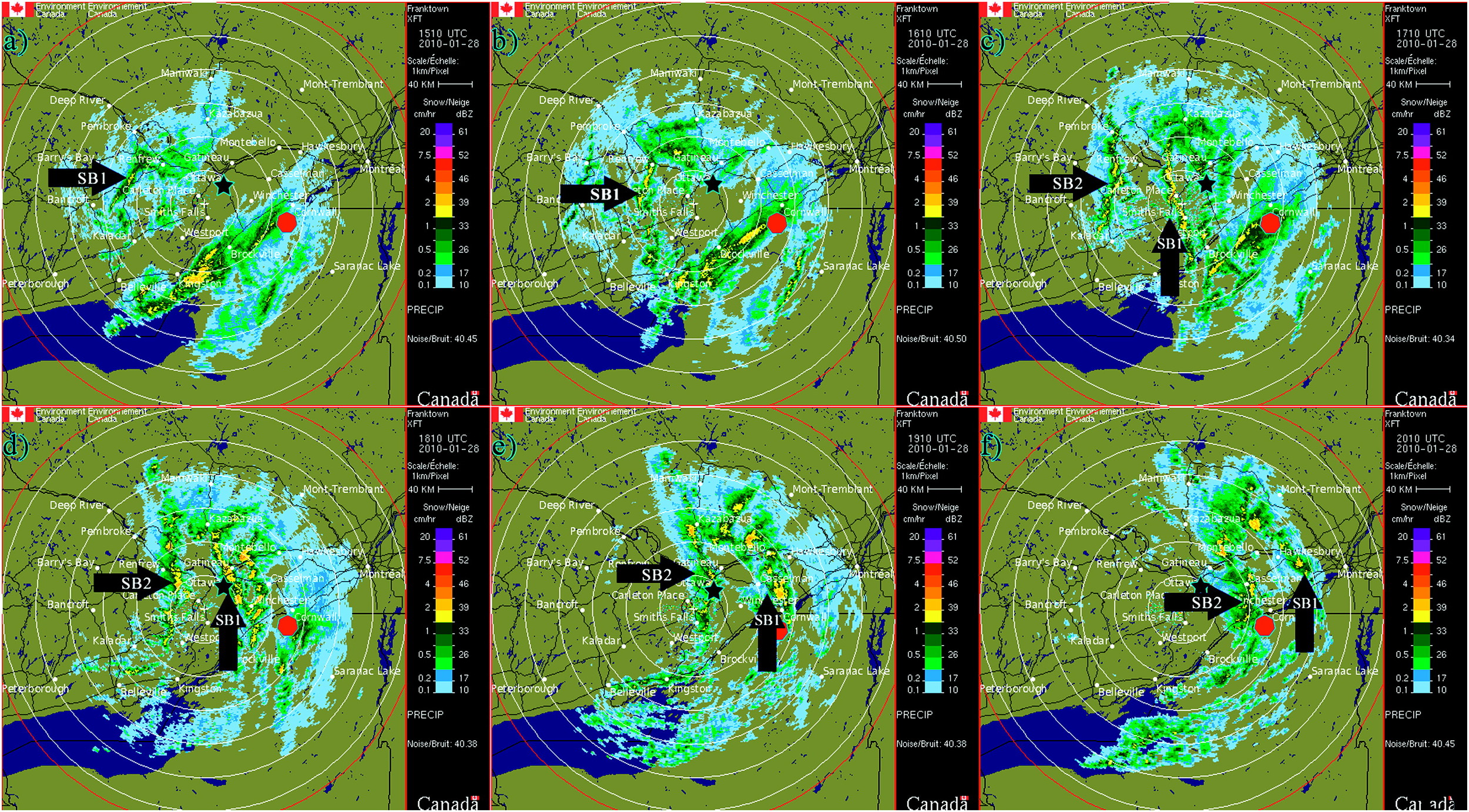
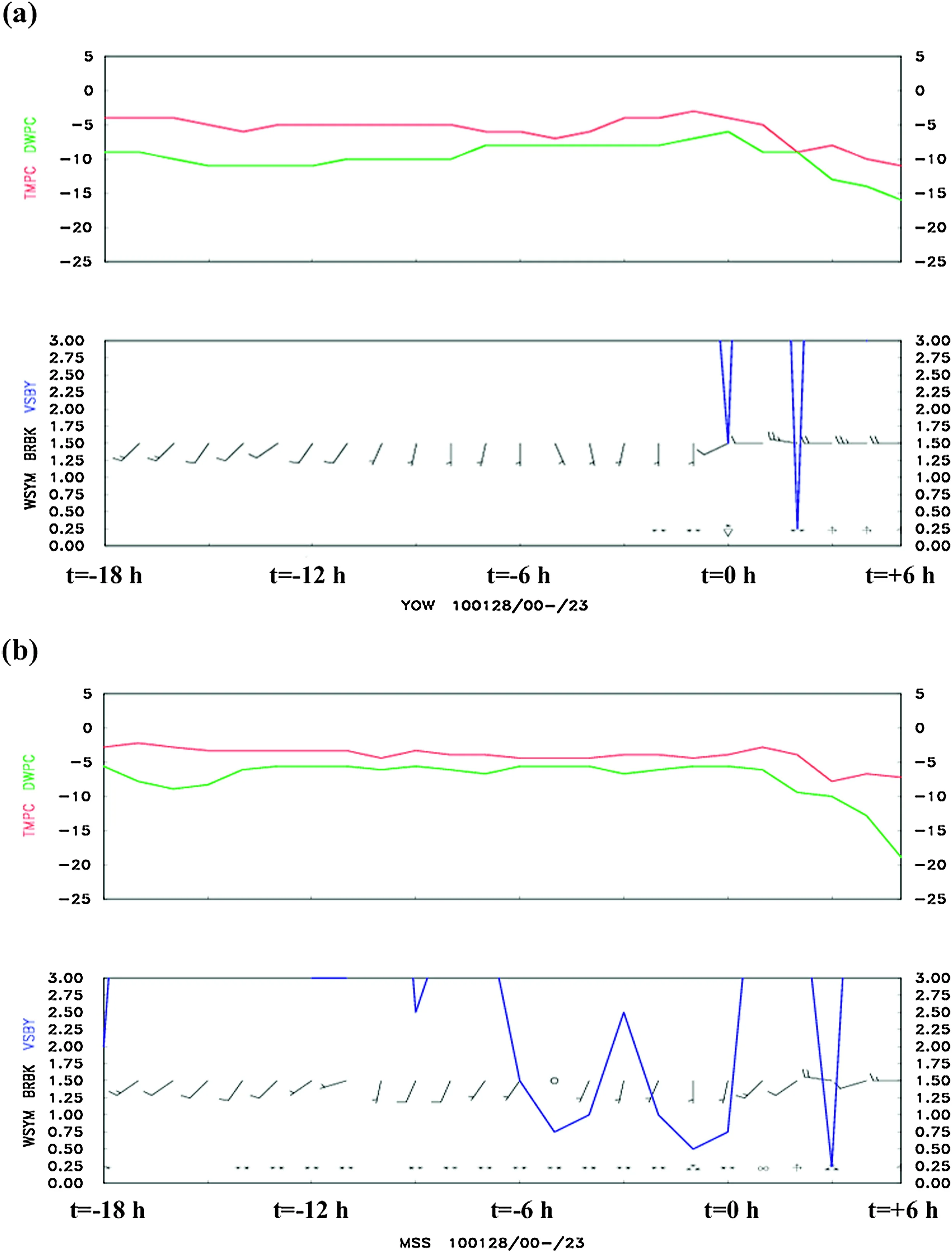
My initial interest in this topic was sparked by an event in Ottawa, Ontario in January 2010, when two separate squalls moved through within 2 hours of each other, reducing visibility to near-zero. Radar imagery, meteograms, and soundings from that event are shown below.
Our research has shown that these events are typically associated with the passage of an arctic cold front, very steep lower-tropospheric lapse rates (see soundings below), and convective and/or conditional symmetric instability (CSI) that is released by a variety of ascent mechanisms, primarily frontogenesis.
Terrain can also play a major role in producing and/or supporting these events, as detailed by our 2014 investigation and numerical simulations of two separate events in Alberta, Canada.

Synoptic-Scale CHARACTERISTICS of MCCs
Our research on MCCs examined the large-scale mechanisms that precede and are favorable for their formation and maintenance.
MCCs are large, circular, primarily nocturnal convective systems that produce a substantial amount of warm-season precipitation in the Great Plains. They are largely dependent on the nocturnal Great Plains low-level jet (LLJ) as a source of warm, humid air. Below is an Infrared satellite animation of an MCC from June 2015. Note the very cold cloud tops.
